Description
Added on the 22/08/2021 18:13:33 - Copyright : AFP EN

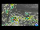
New York, Aug 22 (EFE).- Tropical Storm Henri made landfall at 12:15 am Sunday near the town of Westerly, Rhode Island, packing maximum sustained winds of 60 miles per hour, according to the Miami-based National Hurricane Center, and bringing flooding, wind damage, power outages and flight cancellations across much of New England.Winds, storm surge and heavy rain are the main effects of Henri, which - although it weakened from a hurricane back to a tropical storm on Saturday night - is battering the coast of New York state and southern New England.(Camera: CJ GUNTHER)SHOT LIST: THE EFFECTS OF STORM HENRI IN WESTERLY, RHODE ISLAND, UNITED STATES.

Furious winds whip the coastline by the Montauk Point Light on the easternmost point of Long Island, as tropical storm Henri approaches. IMAGES

East Hartford (Connecticut, USA), Aug 23 (EFE / EPA) .- Henri has gradually weakened as it continues to move slowly along the northeastern coast of the United States, bit it is still forecast to bring heavy rainfall, flooding and even an isolated tornado or two on Monday to portions of southern New England.In its latest bulletin on Henri, which was a hurricane over the weekend but is now a post-tropical cyclone, the Miami-based National Hurricane Center said the system packing maximum sustained winds of roughly 35 kilometers per hour (25 miles per hour) is moving slowly toward the east-northeast, a path that will eventually take it out to sea.(Camera: CJ GUNTHER) SHOT LIST: THE HOCKANUM RIVER AFTER STORM HENRI PASSES THROUGH LABOR FIELD IN EAST HARTFORD, CONNECTICUT, US.

Workers shovel snow and utility vehicles clear paths on Times Square in New York as a snow storm blankets the US East Coast. IMAGES

Boston is blanketed in snow as a major snow storm hits the US east coast, with forecasts saying up to 2 feet (60cm) of snowfall is expected. IMAGES


 |
Support : Technical
|
Support : Technical  - Content
  - Editors